Friday, November 22, 2013

The Brilliance of Early Frescoes

The Loggia and the Sistine Chapel are probably the best known early fresco paintings that are recognized today, but fresco wall decoration was not a new idea when the Vatican contracted hundreds of talented professionals during the main period of embellishment, during the 15th to 17th centuries. Pictures were painted on walls for thousands of years before this.

Raphael's frescoes at the Vatican were revered from the time they were painted early in the 16th century. 150 years after their creation, from
1670-1677 Pietro Santi Bartoli (1635-1700) endeavoured to capture the beauty and essence of Raphael’s classical frescoes of maidens and men, centaurs and other mythological elements, from the Sistine Chapel in Rome.

A century later, Swiss architect and engineer Domenico Fontana (1543-1607) was responsible for much of Rome’s redevelopment. In 1600 he accidentally discovered the buried region of Pompeii during tunnelling for the construction of a viaduct. Not then identified as a great municipium, dedicated excavation of these ruins did not begin until 1748 - and haphazardly continued for the next 112 years. 

Another great municipeum of the 1st century, Herculaneum was not discovered until 1709 when men digging a well uncovered a decorated wall of the city. A town had been built above it, so excavation did not begin for 30 years. Artifacts and decorated walls from Pompeii and Herculaneum were illustrated as they were uncovered. Engravers were employed to transpose them onto plates for prints to be made to circulate the findings.

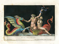
Some of the finest classical engravers of the day were employed to engrave the frescoes for the most important 18th century archaelogical work Le Antichita di Ercolano Esposta (The Antiquities of Herculaneum Exposed), published in Naples between 1757 and 1792.

 Some of these wonderful copperplate engravings have cross-hatched shaded sections to show where paint or mosaic had been destroyed - and remind us of their source.

Not only is it amazing that these frescoes survived and were rediscovered, it is also amazing that the fine engravings depicting them survive today. They are, after all, "just pieces of paper" as someone pointed out the other day. These beautiful antique prints represent art forms from hundreds of years ago.

Before modern technology, circulation of any information had to be carved or drawn onto a plate for printing. (For more information on these early printing methods check out our website Library http://www.antiqueprintclub.com/t-library.aspx.)

If you would like to see  and perhaps own your own beautiful 18th century classical artwork, please return to our website at http://www.antiqueprintclub.com/c-22-classicaldesign.aspx or better still, see them exhibited at the Brisbane Antique Emporium, 794 Sandgate Road in Clayfield - open every day unless a public holiday.

Monday, September 2, 2013

Australia in 400 Years of antique maps & prints

Since closing our Milton gallery at Camford Square, Derek and I have been surprisingly busy - maps, prints and books bought online, meeting customers at our shops in the Brisbane Antique Centre at exit 30 (Beenleigh-Redland Bay Road), and sharing refreshments with visitors to the Antique Print Club-house on Mt Nimmel in Neranwood.

We now also have regular exhibitions in Clayfield at Brisbane Antique Emporium (Open Daily at 794 Sandgate Road – free parking, off Junction Road). The current exhibition shows 400 years of Antique Maps & Prints of Australia.

As recently as the 17th century Terra Australis Incognita (unknown southern land) represented European opinion that a large landmass at the South Pole balanced the populated countries of the northern hemisphere. Including “curious” in their titles, even early 18th century maps wrong coastlines for Australia - until James Cook discovered and charted the east coast in 1770.

Early European engravings showed decidedly strange interpretations of Australia’s unfamiliar marsupials. Engravings of our birds and animals include the ‘kanguroo’ on Captain Cook’s voyage (more accurate in shape than many images from the First Fleet settlement). 19th century beautiful large hand-coloured lithographs of Australian birds and mammals were published by John Gould. 18th century hand-coloured engravings of distinctive Australian flora had finely engraved dissections of flowers. Some in the 19th century used uncoloured sections to emphasize foliage detail. Exquisite hand-coloured botanical lithographs c1840 are beautiful decorative artwork.

 One of the earliest and undoubtedly the most famous early view of Australia is of Cook’s Endeavour in the river near Cooktown in north Queensland, where it was repaired after running aground on the Great Barrier Reef. Engraved scenes of early country views and city architecture, tell us of life in colonial Australia. Engravings and lithographs depict the hardships endured by immigrants in carving homes and livelihoods from the land, and include wonderful S.T. Gill character studies of those seeking gold, and engravings of other more humorous incidents. Formal Victorian customs and dress were not suited to life in the harsh Australian environment. We are lucky that early settlement and development was graphically recorded in engravings to provide images for publication and circulation back in Europe – and for us to appreciate today! You'll find many more at http://www.antiqueprintclub.com/ 
Let us know if we can be of assistance.. and Gift Certificates for any value are always available http://www.antiqueprintclub.com/p-1947-gift-certificate-for-antique-maps-prints-or-books.aspx..

Sunday, July 14, 2013

Three Important Mapmakers

In Northern Europe in 1472 the first woodblock map was published by inking a raised type-face that had been created by carving away from the image to be printed. In Italy a different process was soon developed to show the fine detail of each map by copperplate engraving.
Engraving for the printing of images was painstaking and highly skilled work. Engraving was made more difficult by having to be done in reverse as a mirror image, so that the image was the right way round when printed for publication. Early maps were printed on hand-made paper. Both the paper and the copperplates were expensive. Fortunately carved lines on copperplates could be beaten flat and re-engraved with updated information.

Quad. Terra Australis c1600
Long before the invention of the printing press (around 1440) ‘the father of cartography’, Claudius Ptolemaeus (87-150) based his theories of the universe on those of the ancient Greeks. Ptolemy was a Greek mathematician, geographer, astronomer and astrologer lived in Alexandria when it was the most important centre of learning in the world, and the centre of trade between east and west. His most important works were Almagest on astronomy (presenting the theory that the universe revolved around earth), and Geographia (the first organised presentation of geography using grid structure and mathematical projections for maps, and the terms ‘latitude’ and ‘longitude’). It was Ptolemy who theorised that there must be a great south land to balance the weight produced by the known land masses of the northern hemisphere, to keep the earth from tipping up. His theories were maintained for over 1,500 years.

In the 16th century, the most important period in the development of map-making, Gerardus Mercator (1512-1594) was also a mathematician, cartographer, designer of mathematical instruments, and globe-maker. Mercator drew and engraved his first map (of Palestine) in 1537, but he established his fame in 1569 with an enormous eighteen-sheet World Map, drawn to his new ‘Mercator Projection’ with increasing latitudes. 'Mercator's Projectio' can be found at the top of many flat projections of the world that have been published over the years since. Although he was not the inventor of this type of projection, Mercator was the first to apply it to navigational charts so that compass bearings could be plotted in straight lines which greatly assisted navigation. Mercator also designed instruments to improve the method of land surveying.
 
Tallis. Mercator Projection c1850
Mercator’s love of design extended to his copperplate-engraving of maps, and his introduction of italic wording. Gerard Mercator re-engraved as closely as possible the maps for a new edition of Ptolemy's Geographia, and published a three part Atlas which became known as The Mercator Atlas.  Although Mercator was the first to refer to a book of maps as an Atlas (after the learned philosopher, mathematician, astronomer and legendary King of Libya), ‘Ortelius’ Abraham Ortel (1528-1598) is credited with the first formal world atlas, Theatrum Orbis Terrarum published in 1570. It was the first book containing a systematic collection of equal-sized maps, compiled from contemporary knowledge and not based on Ptolemy's theories.

Ortelius worked in the great commercial centre of Antwerp. He travelled widely through Europe and used his cartographer contacts to gather maps which he drew and Frans Hogenberg engraved. His Theatrum appeared in numerous editions up until 1612 - in different languages and updated with the latest knowledge and discoveries. Ortelius shared information of the latest discoveries with Mercator who encouraged and advised him. Being more commercially minded than Mercator, Ortelius also adapted Mercator’s maps for his own publications.
 
Bellin. New Holland (Australia) c1583
Original engraved maps prior to the 16th century are rarely seen today. Surprisingly, considering the fragility of paper, a wide range of 17th, 18th, and 19th century antique maps are still available.  As with antique prints of other subjects, the value of antique maps depends on rarity, quality and condition.

You can buy an original map over one hundred years old for as little as $50 or for more than $15,000. Cost does not determine the amount of fascination they provide – from the paper and printing method used in making them, the wonder of their survival, and of course, the variation of information shown on them. There is a fantastic selection at http://www.antiqueprintclub.com/c-1-antique-maps.aspx

The inaccuracies of earlier coastlines now entertain us, but as centuries have changed political boundaries, the varying names and borders of regions and countries provide a graphic reminder of the past. The more you study them the more you are hooked - an affliction referred to as ‘map pox’!

Thursday, May 2, 2013

Fascinating original Antique Prints & Antique Maps.

ANTIQUE MAPS and ANTIQUE PRINTS from 100 to 400 years old:

We have a great selection of maps and charts of the world - most countries from most centuries.. showing earlier beliefs of land formations, and charting of exploration and discoveries.

For many centuries (pre-GPS), navigation of our oceans was by Compass Rose and the stars as shown in these Globes..


Our antique prints are original etchings, engravings and lithographs that were done to circulate information of important discoveries and discoverers, events, customs and beliefs.
 Antique Prints cover most subjects. There is always a subject to compliment an interest. Just ask!

Some of the earlier maps and prints are obviously inaccurate - and are more interesting because of this. Having been antique dealers for more than 35 years, we have many thousands of antique maps and prints in stock, and add to our website continually; so let us know your interests.

You can purchase securely online 24/7 from our website http://www.antiqueprintclub.com  -
or visit our galleries in Australia (open every day - except public holidays):
at the Brisbane Antique Emporium at 794 Sandgate Road, Clayfield, and the
Brisbane Antique Centre at Exit 30 from the M1 motorway (at the beginning of Beenleigh-Redland Bay Rd).
Visits can also be made by prior arrangement to the Antique Print Club-house at Neranwood (email sales@antiqueprintclub.com).

We hope you enjoy our Blogs. For more information on the intricacies of antique maps and prints, you might like to visit our website Library http://www.antiqueprintclub.com/t-library.aspx

Saturday, March 2, 2013

Paris fashion southside, at the Brisbane Antique Centre


HOT AIR & COOL IMAGES..
Have you been anywhere different lately, or are you visiting the same old ‘haunts’? If you live in south-east Queensland, make sure you visit the Brisbane Antique Centre on Brisbane's south-side: at Exit 30 on the Pacific Highway (at the beginning of Beenleigh-Redland Bay Road). A Montgolfier hot-air balloon is painted on the sign outside the Centre. If you can't find them, phone but don’t expect to find hot air inside the 2,200 square metres of air-conditioned space with antiques and cafe. Well, that’s not quite right according to Derek Nicholls, referring to my descriptions of finer points of the antique maps and prints in the Antique Print Club 'shop' there. 
Fortunately for me, enthusiasm is usually contagious. It’s always nice to be able to share one's pleasures with others. Derek and I meet up with customers at the Brisbane Antique Centre by prior arrangement.
Open daily, the Brisbane Antique Centre is ever-changing. It's great for browsing and buying - with a wide range of antique, vintage, and historic items, priced from $10 up. The more unusual items include a beautiful cream vintage Rolls Royce. No. that one is not $10! You'll be surprised at what you find - particularly when you take the time to look among the antique prints. 


We have more than a thousand antique maps and prints to choose from. All have descriptions and prices, and are mounted or framed in conservation materials. They are particularly fascinating when you consider the work involved in producing them. All are original works of art from the 17th century to the 1920's. 

From our website the demand is from worldwide buyers - so if you would like to buy, do so while they are available. As they are original artwork, no two are the same - in fact it is most unusual to find two of the same subject, as it is hundreds of years since they were made and paper is fragile. They will provide enjoyment for years to come, so meanwhile, check them out on our website at http://www.antiqueprintclub.com/